
06 Oct Crow Canyon: Update and Praise
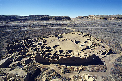
Pueblo Bonito, Chaco Canyon
Editor’s note: Crow Canyon Archaeological Center is located in southwestern Colorado, a rewarding day trip from Telluride of a little over two hours each way.
For over 28 years, the on-campus staff has made its business to study and teach human history, particularly the rich history of the ancestral Pueblo Indians (aka, the Anasazi), who inhabited the canyons and mesas of the Mesa Verde region over 700 years ago. Crow Canyon may be regional, but its vision is global: “To expand the sphere in which we operate, both geographically and intellectually, and show how the knowledge gained through archaeology can help build a healthier society.”
And the Center walks its talk: all of its award-winning programs are developed in consultation with American Indians, enhancing the archaeological perspective of scholars with a cross-cultural perspective.
Go here to read about some of those programs:
Basketmaker Communities Project
Pueblo Community History Project
And for an overview of trip options in the surrounding area, hosted by Crow Canyon experts, read the following article by part-time Telluride local, San Francisco-based writer Clay Shivers. The original overview (published on September 29, 2013) appeared in the Travel section of the Washington Post.
The mesas loom above us on either side as our raft drifts down the San Juan River. Sheer cliffs of crumbly sandstone and shale rise hundreds of feet into the air, eating into the blue sky, of which only a sliver is visible. On the rocky shore to our left, a bighorn ram looks up from its grazing to calmly take us in.
We’re in the middle of the Navajo Nation and in the heart of the Four Corners area — the intersection of New Mexico, Arizona, Colorado and Utah. For years I’d driven through this arid, haunting part of the country, wanting to explore it but overwhelmed by its vastness and rugged beauty and not knowing where or how to begin.
Then I found out about a working archaeological research facility in Cortez, Colo. The Crow Canyon Archaeological Center is a nonprofit organization that funds its research in part by guiding people like me on trips led by archaeologists who have spent their careers in the area, digging into the past. What could be a better way to see the country, I figured?
This is the last day of our five-day trip, and I’m amazed at how much I’ve seen and learned. My archaeological guides, Mark Varien and Ricky Lightfoot, are true experts on the region, and though not all their expertise has successfully made its journey from them to me, enough has to reveal this country to me in a new light.
Four days earlier, I’d walked into a meeting room at the Courtyard by Marriott hotel in Farmington, N.M., filled with the fight-or-flight response I always get whenever I meet new people. There were nine others in the room: Mark and Ricky, two drivers and five other intrepid explorers. We civilians had all taken the recommended packing list way too seriously and looked as if we were about to explore the jungles of Borneo.
Mark and Ricky were dressed more or less like cowboys: bluejeans, snap shirts and cowboy boots. They wouldn’t stray from this clothing choice for the remainder of the trip.
Mark turned out the lights and showed us some slides and gave us an overview of the region and told us what we were going to see, and I didn’t really understand a word of it. (He used lots of archaeological words. I would later purchase a book he wrote and not understand any of that, either.)
Civilizations come and go
The next morning, we headed for Chaco Canyon. This is a place that looks like something you’d expect to find in the deserts of North Africa. Yet here, for 400 years, from the 9th to the 13th centuries, the complex civilization of the Ancestral Pueblo, or Anasazi, once thrived. Our very own Timbuktu.
Getting to Chaco is no easy task. We drive on small farm roads, cross from Colorado into New Mexico, turn off onto a hardpan dirt road, and then drive for 20 excruciating miles. Our two vans vibrate as if they’re going to crumble to death at any moment, as dust swirls in the air. Mark and Ricky use the van’s intercom to explain everything that we’d be seeing if we weren’t driving through a dust cloud. And I mean everything. Trees, rocks, plants, weeds, weather, buttes, mesas, ancient riverbeds, wildlife — being an archaeologist apparently makes one an expert on just about everything.
For a brief moment, the dust clouds part, and I point off to the right at an octagonal structure residing next to a trailer home and two red pickup trucks.
“Is that a hogan?” I ask. I’m already starting to pick up the lingo. Yesterday I would have seen just a trailer home. Now I know a hogan to be a traditional Navajo dwelling, the door to which always points east.
“That’s a female hogan,” Mark says, staring off into the distance like a poker player. “You don’t see too many male hogans anymore.”
My next question (“Are you pulling my leg?”) goes unanswered, because we’ve finally arrived. We get out of the van and walk to Pueblo Bonito, the most impressive of Chaco Canyon’s ruins. D-shaped and five stories tall, with 650 rooms, it was the largest of what archaeologists call great houses, and it was majestic in its time: Until the mid-19th century, it was one of the largest structures in the United States. It stands at the bottom of a cliff wall, part of which has since toppled onto it, and was built over the course of 300 years, using masonry that’s three feet thick in places and wooden support beams made from ponderosa pines.
“Welcome to downtown Chaco,” Mark announces. Theories abound, but Mark believes that Chaco at one point supported a population of about 4,000.
Because of the punishing road, we have the place to ourselves. As we walk through the rooms, we duck through small square doorways, trying not to bump our heads on 1,200-year-old wooden beams, and listen as Mark and Ricky go into great detail about what was found in each room, what each room was used for and what a typical day in a pueblo was like. Archaeologists (some professional and some not so) have excavated thousands of turquoise pendants and beads here, along with macaw skeletons, copper bells, and seashells from Mexico, hinting at sophisticated and far-reaching trade routes.
Most impressive in Pueblo Bonito are the Great Kivas, giant circular communal chambers/religious amphitheaters that were cut into solid rock at a time when digital levels and computer precision were still centuries away. I’m mesmerized by how perfectly round they are.
That the United States has been inhabited for a really long time isn’t something that I’d ever thought about. A year earlier, I’d been in Ireland, where everything can seemingly be traced back to the time of the Druids — even the dive bars — and I found myself suffering from Look How Old Everything Is Compared to the United States-itis. Chaco Canyon is therefore a revelation. It’s as intriguing as Stonehenge and as magnificent as the works of the Aztecs or the Maya.
Chaco would have been a tough place to call home. Then, as now, the temperatures could drop well below zero in the winter and routinely hover in the triple digits during the summer. And food and water was and is scarce. Which would explain why, when we sit down at a picnic table to eat lunch, crowds of curious and intrepid squirrels and woodchucks gather around.
Lunching in front of an audience of beady-eyed varmints at a time when the news is filled with the deadly hantavirus is a little disconcerting. So we eat rather quickly and decide that it’s time to move on. But not before I get the answer to my hogan question. Mark tells me that male hogans, now out of style, were round, with a cone-shaped roof, whereas female hogans are octagonal, without the cone.
There’s not a cloud in the sky, and the sun is beating down on the back of my head as if the large floppy hat I’m wearing didn’t exist. We can see evidence of a wildfire in the distance, and skeletal trees litter the horizon like giant charred toothpicks. Occasional gusts of wind blow red desert dust into the air.
It’s Day Two of our trip, and we’re in the heart of Ute Mountain Tribal Park, part of the Ute reservation, far from the tourist sites, visiting a cliff dwelling called Eagle’s Nest. Around 800 years ago, during a period of disappearing resources and increased conflict, the Anasazi, for their own survival, moved north to the Mesa Verde region of southwestern Colorado and began building their homes beneath the lips of canyons. From below, they look like oversize hornets’ nests. From above, where I am, perching precariously on a sheer precipice, they look like death traps.
To get to Eagle’s Nest, I’ve had to climb two sets of old wooden ladders and squat-walk along a slight indentation in the rock beneath the cliff. It’s narrow, and the Anasazi weren’t big on railings. I hugged the rock wall to my right and pretended that the left didn’t exist.
As I sit in Eagle’s Nest, my mind is never far from my perilous location. Mark, who’d made the climb rather effortlessly in his old cowboy boots, stands carelessly inches from the edge and points out aspects of the masonry and its significance. He indicates places where you can still see thousand-year-old fingerprints in the mortar.
This is not Mesa Verde National Park, the more commercialized Anasazi ruin. There are no paved walkways or helpful park rangers telling amusing stories about things that never happened. All around us, just lying about, are bits and pieces of ancient history: potsherds of various types, arrowheads, the shiny skulls of long dead animals.
I look out at the canyon below and try to imagine what must have gone into obtaining the daily necessities of food and water and think about how dangerous life must have been to make living in cliffs seem like a good idea. I’d polished off the water in my canteen some time ago, and I’m thirsty, but I’m not about to move. On the other hand, I doubt that obesity was much of a problem when dinner involved climbing up and down several ladders and walking miles and miles in search of prairie dogs.
According to Mark and Ricky, the Four Corners area is littered with sites like this. Because of the desert climate, a sparse population, and miles and miles of undeveloped government land, there are more archaeological sites in this condensed area than anywhere else in the United States and all but a few places in the world. Most are only partially excavated or not excavated at all, waiting for the archaeologists of the future, armed with technology not yet invented, to come along and fill in the holes in today’s archaeological theories.
I’m much happier, and probably a better student, when we return to solid ground. I’m also happy to be back in the van, which is gloriously air-conditioned and filled with ice-cold water.
The last day of the trip starts with a cold yet beautiful dawn, with stars in the night sky so numerous that I’m left rather stupefied and speechless. I’ve been to places where you can see lots of stars at night, but nothing like this. They seem to merge with the horizon.
Floating down the San Juan River takes you through the iconography of the West that John Ford made famous. In fact, the cabin used as the home of John Wayne’s character in “The Searchers” is nestled along one bank.
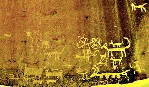
But our journey has a purpose: We’re on our way to Butler Wash, a great panel of petroglyphs, some of which date back more than 4,000 years.
Off to our right as we come around a bend in the river, we can see vague pecked-out shapes against a dark cliff wall. Our Navajo river guides, Marcus and Greg, pull the rafts ashore, and we hike up to the panel. There are representations of bighorn sheep, snakes, atlatls (a cross between a slingshot and a hand-held catapult, used for hunting) and figures that appear to have antennae growing out of their heads.
The oldest petroglyphs are high up on the wall and sport long legs and trapezoidal torsos; the drawings get newer as they work their way down. Some of the more memorable are human representations that resemble lizards with clawlike hands and feet. This is yet another reminder that this part of the world was inhabited long before Christopher Columbus ever set sail.
Back on the river, Ricky gives us a lesson in geology — 300 million years of it. Navajo sandstone, Mancos shale, Permian shale, anticlines, synclines and monoclines. All of it crumbly and crumbling, all of it slowly being eaten away by the brown/green ribbon in the middle.
Thanks to the geologist from Northern California who’s part of our group, I’m now armed with my newest geological word: hoodoo. A great word, hoodoo. A hoodoo is a rock formation in which a large piece of rock is balanced on top of a much smaller piece. I start looking for them. The best example is Mexican Hat, and it’s impressive. It looks like a rock sombrero sitting atop a giant rock person’s neck. And, with the rock’s red coloring, it’s the same color as my neck.
The desert has a lot to say
We’ve come to the end, and now we’re taking it all in. We’re high above Monument Valley and seemingly on top of the world. To get here, we drove up a precarious dirt road full of switchbacks, along which Ricky gleefully pointed out a handful of cars and trucks that hadn’t made it.
We sit on folding chairs, drinking margaritas and watching the sun work its way down the horizon. Mesas and buttes and the tiny San Juan River far below are lit up in dramatic hues of oranges and yellows and dark reds. My shadow trails behind me for more than a hundred feet.
As I sit looking at many of the same sights I’ve driven past for years, I realize that they have been transformed. Instead of some unknown pile of rock, I now see Jackson Butte. I now see either dark gray Mancos shale or ochre-red Navajo sandstone. I see where inland seas have created buttes and mesas.
The desert is showing me things that I couldn’t see before. And with the help of Mark and Ricky, it has also been telling me a story.
Sorry, the comment form is closed at this time.